top of page

The last post showing an aerial view of the Sullivan's Island and Breach Inlet sandbars at low tide was very popular with the ocean athlete and boating communities. It gives a snapshot of what the sandbars looked like in April 2023 and it will be interesting to see how they change over time, as sandbars often do around here. Someone requested I provide the same for the sandbars around the Stono River Inlet and south Folly Beach. Great idea! So here you go...


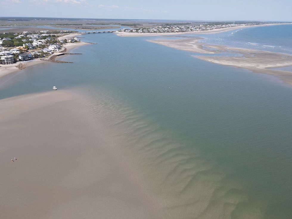
The following aerial drone video and photos were captured on May 30, 2023 at dead low tide.


The first clip in this video below is the view from the east tip of Kiawah Island looking east towards south Folly Beach. It begins by flying east over Bird Key. The second clip is the view from the ocean side of south Folly Beach looking inland, and moving from east to west.


Above: This is the view looking south from south Folly Beach. The upper right hand corner is the eastern tip of Kiawah Island.


Below: Kiawah Island at top and Bird Key in the middle right of the photo.

The following 6 photos are a 180 degree view from west to east.


Above: Looking east at the south tip of Folly Beach


Above & below : Another view looking west from south Folly Beach at Kiawah Island and Bird Key


Above: Looking towards northwest where the Folly River meets the Stono River. At left is the north tip of Bird Key.


Above: Snake Island and the Folly River between Bird Key and the south tip of Folly Beach


Above: Looking towards the east at Folly River and the south tip of Folly Beach


Above: Looking at Snake Island at the top of the photo. At right is the very southern tip of Folly Beach.


Above: the view from the southern tip of Folly Beach looking towards Bird Key, Kiawah Island, and the Stono River at top of the photo.


Above: Looking south - the eastern tip of Kiawah Island and the southern tip of Bird Key at upper right of the photo.


Above: Looking south, at top of photo is Bird Key and Kiawah Island


Above: waves outside of the inlet between the southern tip of Folly Beach and Bird Key



1,076 views0 comments
Writer's pictureMac

The waters off Sullivan's Island have been a watermen's/waterwomen's playground for a long time. And those who've paid attention over the years know the sandbars off the beach are always changing, which in turn is always changing the experience when playing out there in the ocean.


On April 20th, I captured some aerial drone video and photos of these sandbars in their current state on that day at dead low tide. There has been a lot of interest from the local ocean athlete and boating community on where the sandbars are located and how they look, so I'm posting it here for everyone to review...and to refer back to. Because by this Fall and certainly by next year, I'm sure it will look different. By how much? We'll see...but I'll try to document it in this same fashion once or twice each year. It will be fun and interesting to see the changes over time.


The following 2 minute video has 3 scenes:

1) 360 degree view of all the sandbars (starting with view towards the lighthouse)

2) left (south) to right (north) view of the main sandbar along the beach (from oceanside, looking towards the beach)

3) view of Station 28.5 to Station 30 area (from oceanside, looking towards the beach)


This first photo is looking directly towards Station 28.5 from outside the sandbar. The next several following photos are in sequential order from left to right in 360 degree view.


Another view of the area in front of Station 28.5 and Station 29


Breach Inlet


The area in front of Station 29 and Station 30


Station 30


Breach Inlet and the sandbars on the Isle of Palms side (this and the next two photos)


Looking towards the outside of Breach Inlet


The narrow channel/inlet in front of Station 28.5


Looking out at the rock jetty at Station 30


Looking towards Station 30 from in front of Station 28.5


Looking towards Station 30 and Station 29 from Breach Inlet


Looking directly towards Station 30


173 views0 comments
Writer's pictureMac

Updated: Apr 8, 2023

Saturday, April 1st was one helluva of day in the Charleston area. A ton of out of towners were visiting for several area events. Most notably, the annual Cooper River Bridge Run was happening, with approx 27,000 people taking part. The Credit One Championship Women's Pro Tennis event was getting under way. And other events and festivals were happening all over town and the surrounding area.


But for the Charleston Ocean Athletes, it was a day long anticipated that week thanks to a favorable forecast for the prevailing warm southwest winds and low level jetting (meaning the warm southwest wind over the cold ocean water wouldn't cause fog and light wind). It meant that spring was really finally here, the "third winter" was behind us, the pollen invasion was about done, the water was warming up and the winter marine layering was almost finished. This meant the beaches were finally going to get some consistent wind! Everyone was just hoping this wouldn't be some cruel April fools joke, whereby the forecast would fall through and leave everyone crying the blues on the sand.


Alas, the forecast proved out and we got consistent SW wind all day in the 22-27 mph range across all the beaches, along with 3-4 ft waves to play in. Yours truly got out to windsurf at Isle of Palms for a good bit, enjoying the action on the water with five other windsurfers and a couple of kitesurfers. Then I got behind the camera and roamed around Isle of Palms between 6th Ave and 3rd Ave, and then Station 28.5 at Sullivan's Island. There was big air, wave carving, and just plain good old speed. What a great day it was for everyone, ala the April Fools.


I hope you enjoy the video below (play it in HD full screen and turn up the sound!), plus all the photos below that.


~ Mac ~


If able, play in full screen HD and turn it up. Charleston Ocean Athletes featured in the video include (in alphabetical order): Mac Barnhardt, Chris Busacca, Peter Hess, Scott Hyland, Bart Liebmann, David Schar, Trey Sedalik, Scott West, among several others.


Video & editing by Mac Barnhardt

GoPro POV footage by Bart Liebmann & Scott West


All photos below by Mac Barnhardt


Dave Cavanaugh bottom turning into a juicy wave


Dave Cavanaugh throwing buckets


Scott West bottom turning back into the wave


Bart Liebmann wavesailing


Peter Hess just ahead of the froth


Dave Cavanaugh eyeing the wave


Dave Cavanaugh carving it up


Looking south towards 3rd Avenue & Sullivan's Island


unidentified sending it at 3rd Avenue


Chris Geganto big air


Alli Lehr taking advantage of the conditions


Trey Sedalik in the shallows


Gerrit Neve on the wing foil


Bobby Funcik airing it out


Jonn Meyers carving out a path


a familiar sight along our coast


Trey Sedalik mid-flight board grab


Welcome To The Jungle


Chris Busacca speed sailing on the inside


David Schar throwing spray


Scott Hyland inverted


unidentified going for the mid-air board grab


unidentified enjoying the big day


Chris Busacca off the lip


unidentified chopping it up


unidentified sending it


Scott Hyland of Sealand Sports was on the loose


Chris Busacca was finding ramps all over the place


unidentified mid-flight


David Schar looking for a landing spot


Scott Hyland board sliding


43 views0 comments
bottom of page